

Getting ready for a Michigan road trip? Explore Northern Michigan’s most breathtaking trails, top hiking spots, and must-visit destinations along the way.
If you are searching for a road trip destination in the United States that combines natural beauty, peaceful drives, and unforgettable outdoor experiences, Michigan deserves serious attention. While many travelers focus on the country’s more famous routes, Northern Michigan quietly offers some of the most rewarding landscapes for anyone who enjoys scenic drives, hiking, and discovering places that still feel authentic and uncrowded.
What makes Michigan special is how much variety you can experience in a single trip. A short drive can take you from dense forest roads to open lake views, dramatic cliffs, charming small towns, and hidden hiking trails that rarely appear in traditional travel guides. It is the kind of destination where every few hours feel completely different, making the journey itself just as exciting as the stops along the way.
I traveled from Marquette to Traverse City, seeking scenic escapes and lesser-known places worth visiting beyond the usual tourist recommendations. What began as a simple road trip quickly became something much more meaningful.
Also Check On:
After visiting more than 150 countries, I did not expect this route through Northern Michigan to leave such a strong impression, but it did. The combination of manageable driving distances, numerous accessible trails, and varied scenery made every part of the journey feel fresh. One trail led to quiet forest paths, another opened to lake views, and the next revealed landscapes that felt entirely new.
One of the biggest surprises was how easy it is to keep discovering something different without long hours on the road. You are never in the same terrain for too long, which makes the trip ideal for travelers who want variety without exhaustion.
I can honestly say this became one of the most rewarding road trips I have experienced in the United States. In this guide, I will explain exactly why Northern Michigan deserves a place on your travel list and which stops made this route unforgettable.
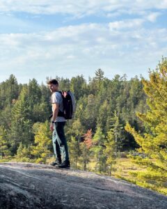
Marquette & Surroundings
Driving distance to the next stop: about 45 miles (1 to 1 hour 15 minutes)
Recommended stay: 2 to 3 nights, including at least one full day
I recommend beginning your Northern Michigan road trip in Marquette because it offers an easy and memorable introduction to the region’s wild beauty. It is the kind of place where nature immediately becomes part of your experience.
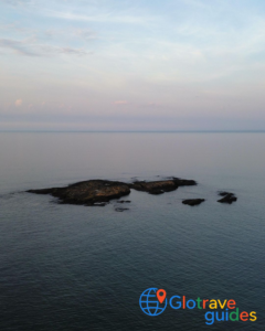
Just a few minutes after arriving, you can already find yourself standing along the shores of Lake Superior, watching waves crash against dark volcanic rock. Even from many hotel rooms, the lake feels close enough to shape the atmosphere of your stay.
What makes Marquette such a perfect starting point is how much landscape diversity is packed into one small area. In one part of town, you can enjoy peaceful shoreline walks with endless lake views, and not far away, you are climbing through wooded trails toward viewpoints that feel surprisingly remote.
One of the highlights is Sugarloaf Mountain, which quickly gives you a sense of the scale of Northern Michigan. The hike is short but steep enough to feel rewarding, and once you reach the top, the view opens dramatically over Lake Superior. It creates the feeling of being deep in the wilderness, even though the trail itself is very accessible.
Marquette is also the most practical place to prepare before continuing deeper into Northern Michigan. It is one of the last stops along this route where you will find supermarkets, larger gas stations, and other essentials conveniently close together. That makes it the ideal place to slow down, stock up, and settle into the slower rhythm of the journey before reaching more remote stretches of the road ahead.
What to Expect in Marquette
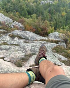
Hiking around Marquette feels like the perfect balance between adventure and comfort. The trails are easy to access and well-maintained, yet the surroundings still feel rugged and untouched. Nature here has a raw energy, and Lake Superior shapes almost every outdoor experience.
One thing you notice quickly is how much the lake influences the weather. Conditions can shift within a short time—sunshine can turn into strong wind, temperatures often feel cooler than expected, and the breeze near the shoreline is usually stronger than farther inland. It is worth dressing in layers, even during warmer months.
Best Hiking Options
Sugarloaf Mountain
This is one of the most rewarding short hikes in the area. The climb is brief but steep enough to feel like a real workout, and the view at the top opens across Lake Superior and thick forest in every direction. It is ideal if you want a memorable panoramic view without committing to a long trail.
Presque Isle Park Trails
If you prefer something easier, the trails around Presque Isle offer beautiful walks along volcanic rock formations with uninterrupted lake views. It is a calm and scenic option, especially for sunrise or sunset.
Noquemanon Trail Network (South Trails)
For longer hikes through the forest, this trail system gives you more distance and quieter surroundings. The terrain is generally gentler, making it a good choice if you want a more relaxed outdoor experience away from the busier viewpoints.
Helpful Tip
If the weather turns cloudy or windy, coastal trails are often the safest and easiest option because they remain accessible and enjoyable in most conditions. On clear days, it is best to plan higher elevation hikes early in the morning before stronger winds develop later in the day.
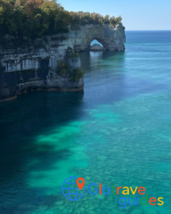
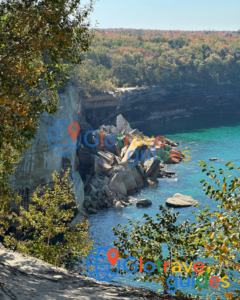
Pictured Rocks National Lakeshore
Driving distance from Marquette: ~45 miles / 1–1.25 hours
Driving distance to next stop: ~75 miles / 1.5–2 hours
Ideal stay: 1 full day trip at Pictured Rocks National Lakeshore and stay overnight at the nearby hotels.
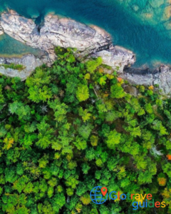
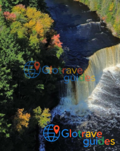
Pictured Rocks is where this road trip truly announces itself. The drive from Marquette already hints at what’s coming. Expect to see long forest corridors, fewer cars, and Lake Superior appearing unexpectedly through gaps in the trees. When I first stepped onto the trails here, the contrast immediately stood out. Towering sandstone cliffs rise above the lake, while quiet forest paths pull you inland. This was for sure the most impressive view of the whole trip, and in my opinion, the best spot to stop in Northern Michigan.
What I loved most about hiking Pictured Rocks was exploring through different environments in such a short distance. Trails like the Chapel Loop combine cliff-top viewpoints, waterfalls hidden in shaded ravines, and long stretches of forest walking that feel meditative rather than dramatic.
What to expect:
This is where Northern Michigan feels truly dramatic. Trails alternate between wooded paths, cliff-edge overlooks, waterfalls, and quiet beaches. Autumn hiking here is calmer, cooler, and far less crowded.
Best Hiking Options
Chapel Loop
If you want the most complete hiking experience in the area, Chapel Loop is one of the best choices. This trail combines several of Northern Michigan’s signature landscapes in a single route—forest paths, dramatic cliffs, waterfalls, and stretches of shoreline walking. It gives you a full sense of how varied the landscape can be without needing to change locations.
Miners Castle Area
For travelers with limited time or those looking for shorter walks, the Miners Castle area offers quick access to some of the most impressive viewpoints in the park. The trails are shorter, but the scenery still feels dramatic, especially overlooking the cliffs and the lake.
Mosquito Falls to Chapel Beach
This route is a great option if you enjoy varied scenery without committing to a full-day hike. Along the way, you pass flowing water, wooded sections, and eventually reach the shoreline, making the hike feel constantly changing and rewarding.
Helpful Alternative Depending on Conditions
On windy or overcast days, the cliff-top trails often feel even more dramatic, with the weather adding a stronger atmosphere to the views. When the sky is clear, combining forest sections with beach access makes the experience more balanced and enjoyable.
We also spent some time at the beach, but even though it looked inviting, the water was far colder than expected, definitely too cold for me to swim.
Tahquamenon Falls State Park
Driving distance from Pictured Rocks: ~75 miles / 1.5–2 hours
Driving distance to next stop: ~90 miles / 1.75–2.25 hours
Ideal stay: Half-day trip
After the openness of Pictured Rocks, Tahquamenon Falls feels like stepping inward. The cliffs disappear, and the forest takes over. Hiking here is less about dramatic overlooks and more about immersion. For travelers used to hiking in Germany, Poland, or Czechia, Tahquamenon Falls might not feel so special. But remember, this trail is not about what you see, but what it makes you feel.
The easy River Trail, which connects the Upper and Lower Falls, became one of my favorite stretches of the entire trip. It was not because of a single viewpoint I encountered, but because of how consistently calming it felt.
What to expect:
This is forest hiking at its best. Trails follow the river through dense woods, with waterfalls as punctuation points rather than the main event. In autumn, the color saturation is intense.
Key hiking options:
- River Trail (Upper to Lower Falls): The classic route, offering a mix of viewpoints and quiet stretches.
- Short Loop Variations: Ideal if you want a half-day hike rather than a full trail commitment.
- Backcountry Sections: For those wanting fewer people and longer walks.
Alternatives:
Tahquamenon Falls is the only route that lets you select between a short walk, a short trail, or longer forest trails. If you feel like exploring spontaneously, you can do shorter trails and move to longer ones if you feel that you need more of it.
Mackinac Island
Driving distance from Tahquamenon Falls: ~90 miles / 1.75–2.25 hours
Driving distance to next stop: ~200 miles / 4–4.5 hours (including ferry time)
Ideal stay: 3 nights (2 full days at least at Mackinac Island to fully immerse in this little piece of land)
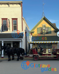
This stop isn’t about pushing distance. It’s about changing rhythm. Mackinaw City is not an obligatory stop. This city serves itself mostly as a gateway, but crossing to Mackinac Island feels like stepping out of modern travel altogether.
Once you leave the car behind, everything slows down. The absence of engines changes how you experience distance, and suddenly walking everywhere feels natural again. With my friends, we chose to cycle around the island, following the shoreline as Lake Huron sparkled on one side and forest rose on the other. The loop is flat, scenic, and flexible (you can stop whenever something catches your attention).
Walking tours through the interior trails offer a different experience. Here you can expect walks through woods and landmarks like Arch Rock, where the natural limestone arch frames the lake far below. In autumn, the island feels calmer and more intimate. Trees begin to turn, ferry traffic slows, and the entire place feels like it’s exhaling after summer. It’s not the most demanding stop of the trip, but it’s one of the most refreshing.
What to expect:
Mackinac Island offers light hiking and long walks rather than elevation or distance. The absence of vehicles changes your pace entirely.
Key hiking and walking options:
- Island Perimeter Road (by bike or foot): Flat but scenic, hugging the shoreline.
- Interior Trails: Short forest hikes leading to Arch Rock and bluff overlooks.
- Quiet Back Paths: Often missed by visitors rushing between landmarks.
Sleeping Bear Dunes National Lakeshore
Driving distance from Mackinaw City: about 200 miles (4 to 4.5 hours)
Driving distance to the next stop: about 30 miles (45 minutes)
Recommended stay: 2 nights, with at least one full day to explore the trails and viewpoints
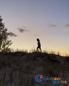
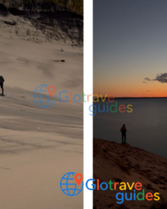
By the time I arrived at Sleeping Bear Dunes, the entire road trip felt like it was entering a completely different chapter. The landscape here stands apart from anything else I have seen in Michigan. Instead of forests and rocky shorelines, the scenery suddenly opens into vast dunes, soft coastal views, and wooded trails that somehow create a landscape that feels both wild and peaceful at the same time.
What surprised me most was how unexpected the setting felt. Parts of it almost resemble a desert, yet only moments later, you are looking out over water with dense forest behind you. That contrast gives the area a character that feels unique, even compared with other famous outdoor destinations in the United States.
Many people say summer is the busiest time to visit, but I found autumn especially memorable. The cooler sand makes walking much more comfortable, the surrounding forests take on rich color, and trails become quieter and more enjoyable. Routes like Empire Bluff Trail offer some of the best views in the park without requiring long or difficult climbs.
This was also one of the few places where I naturally stayed longer than planned. The overlooks invite you to pause, especially toward evening when the light changes slowly across the dunes. At sunset, the atmosphere becomes especially calm, the shadows stretch across the sand, the lake deepens into darker shades of blue, and everything feels slower in the best possible way.
What to expect:
Hiking here blends forest, dunes, and water. Trails are generally shorter but visually rewarding. Autumn hiking is ideal—cool sand, vibrant forests, and quieter overlooks.
Key hiking options:
- Empire Bluff Trail: Short, high-reward hike with sweeping Lake Michigan views.
- Dune Forest Trails: Less exposed, great for midday hikes.
- Bluff-to-Beach Routes: Combine elevation with shoreline walking.
Alternatives:
On windy days, stay on forested trails. On calm days, prioritize exposed dune viewpoints.
Traverse City & Surroundings
Driving distance from Sleeping Bear Dunes: ~30 miles / 45 minutes
Ideal stay: 1 – 2 nights (half a day is enough to see the city)
Traverse City is the soft landing I didn’t realize I needed until I arrived. After days of forests, cliffs, and quiet trails, the town feels lively but not overwhelming. It’s close enough to nature that hiking never feels far away, yet comfortable enough to slow down.
Short walks along the bay, or a stroll through town, feel like a reward rather than an obligation. This is where my road trip ended. No, it was not with a dramatic finale, but with a sense of completion.
What to expect:
Hiking here is optional rather than essential. Trails are easier, landscapes more settled, and the focus shifts toward reflection.
Key hiking options:
Old Mission Peninsula Trails: Rolling terrain with vineyard and bay views.
Boardman Lake Loop: Easy walking after days of heavier hiking.
What made this road trip special?
This route was progressive. It started with high-impact, rugged terrain and slowly moved toward softer landscapes. Driving distances were reasonable, trail access is excellent, and I never felt like I was repeating the same environment.
When it comes to your road trip, I think this trip gives you options. Long hikes or short walks. Exposed cliffs or sheltered forests. Demanding days or recovery days. A road trip in Michigan for me was about flexibility, and this route was built for it.


